The aim of the MarSP project is to support Maritime Spatial Planning (MSP) processes in the three Outermost Regions of the Macaronesia - Azores, Madeira and Canary Islands, in line with the EU Directive on MSP (2014/89/EU), according to an Ecosystem Based Approach.
The specific objectives of the MarSP are:
The work methodology of MarSP project is set by the following work packages (WP):
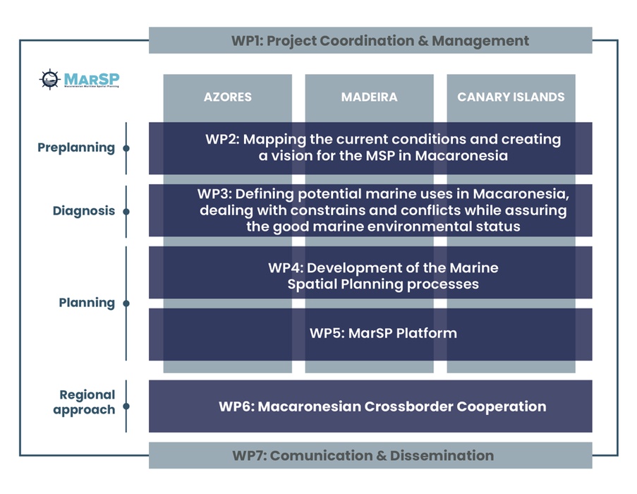
The objective of this Workpackage (WP)is to guarantee a proper coordination, implementation, development and management of the project, in accordance with the GA, controlling the project schedules and budget constraints, while promoting an internal communication between the consortium members. This WP is led by FRCT and involves the participation of all MarSP Consortium members, from the 3 regions of the 2 EU member states (Azores and Madeira - Portugal and Canarias - Spain), that will share the responsibility for the administrative processes, management efforts and technical workout required in each project WP’s.
D.1.1. Kick of Meeting
D.1.2. Establishment of Steering Committee
D.1.3. Internal Consortium Agreement
D.1.4. Inception Report
D.1.5. Progress report - 1
Progress report - 2
Progress report - 3
Progress report - 4
Interim report - 1st period
Interim report - 2nd period
D.1.6. Final report
D.1.7. Final Meeting
The objective of the WP2 is to assess the current conditions that will bound the MSP processes in each of the three Macaronesian regions and create a general vision for each archipelago (Azores, Madeira and Canarias). To fulfil this objective, each region will identify and map the current maritime uses, activities and restrictions, and identify the similarities among the three visions. This workpackage is led by DRAM and involves the participation of DROTA, ULPGC and IEO partners, which will co-share the responsibility for the work carried out in this WP.
D.2.1. Engagement strategy for MarSP including a methodology for stakeholder involvement
D.2.2. Local and Regional Stakeholder Workshops
D.2.3. Guidelines to public participation
D.2.4. Regional Stakeholder´s directory
D.2.5. Report on current maritime uses and constraints in each region of Macaronesia
D.2.6. Regional reports on MSP objectives/visions
The Workpackage 3 objective is to define potential marine uses and the using a scenario-based methodology with multi criteria analysis, dealing with all the constraints and conflicts. Ultimately, this WP intends to identify potential activities uses for the maritime space of Macaronesia, based on the existing knowledge and on the gathered information achieved during the MarSP project. WP3 will contribute to support the decision-making process and therefore, will contribute to support the work of the competent authorities on the allocation strategy definition and the path to the operational MSP steps. This workpackage is led by DROTA and involves the participation of DRAM, ULPGC and IEO partners, which will co-share the responsibility for the work carried out in this WP.
D.3.1. Technical report on potential scenarios
D.3.2. List of areas of Ecological and Biological Significance (EBSAs) or Vulnerable Marine Ecosystems (VMEs) occurring in Madeira subarea
D.3.3. List of Marine Protected Areas
D.3.4. Potential distribution maps for other maritime sectors
D.3.5. Spatial distribution maps of species, habitats and impacts
D.3.6. Matrix of constraints applied to maritime space of Macaronesia
The objective of the Workpackge 4 is to develop maritime spatial plans, more precisely 3 plans, one for each Macaronesian region, having in consideration their specific features/particularities and especially the distinct currently stages in each region. This WP is led by IEO and involves the participation of DRAM, DROTA, and ULPGC partners, which will co-share the responsibility for the work carried out in this WP.
D.4.1. Report describing the Situation Plan
D.4.2. Geographic dataset corresponding to the Situation Plan
D.4.3. Final report defined as a proposal for a law document on the MSP in the Azores, corresponding to the Situation Plan
D.4.4. Model for the Maritime Spatial Plan of the Azores report
D.4.6. Manual of scenarios for maritime spatial planning in the Azores
D.4.7. Report on the stakeholder's Workshop that will be held in Azores to validate / discuss results
D.4.8. Develop a report about the application of MSP in maritime space of Madeira
D.4.9. Stakeholder's Workshop in the Canary Islands to inform and start discussion on the main characteristics of the Maritime Spatial Plan proposal with stakeholders and concerned authorities
D.4.10. MSP Indicators and Monitoring regional reports
D.4.11. Implementation guidelines I - Policy-oriented to guide decision-makers in the long-term maritime strategy
D.4.12. Implementation guidelines II - Stakeholder-oriented to provide guidance for stakeholders in the long-term participation of the maritime strategy
The objective of the Workpackage 5 is to identify, and if needed, extend INSPIRE data model applicable for MSP and case-study of Macaronesia. For this objective, the findings delivered in the keystone paper “Maritime spatial planning supported by infrastructure for spatial information in Europe (INSPIRE)” published in January 2018 will be used. Further, project partners will be trained to use data model and to publish maritime spatial plans using operational data infrastructure, that will be delivered as a part of the MSP Platforms.
D.5.1. Guideline document containing Directive INSPIRE requirements for maritime spatial data management and interoperability
D.5.2. Capacity building actions on geographical data and metadata harmonization
D.5.3. An improved spatial data infrastructure for the Azores archipelago
D.5.4. Online Virtual One-Stop-Shop portal integrated in the Azores MSP Platform
D.5.5. The Madeira MSP Centralized Management System
D.5.6. Canary Islands MSP Platform
The objective of the Workpackage 6 is to describe and analyse the Macaronesia MSP framework and to promote the cross-border cooperation for sustainable growth of maritime economies of Madeira and the Canary Islands, towards the sustainable development of marine areas and the sustainable use of marine resources (Art.1) of MSP Directive. Besides, although there are not international borders between Azores & Madeira, cooperation is also need in regional borders within the same country. For this reason, WP6 will take the opportunity of incorporating Azores archipelago by developing the cooperation tasks in the regional border shared between Madeira and Azores. This workpackage is led by University of Cadiz and University of Seville (UCA/US) and involves the participation of the remaining partners, which will co-share the responsibility for the work carried out in this WP.
D.6.1. Integrated and synthetic diagnosis of the MSP in the Macaronesia
D.6.2. Macaronesia MSP electronic Bulletin
D.6.3. Guidance report on transboundary MSP
D.6.4. Report of lessons learned and best practices available
D.6.5. MSP Governance Guide of the Macaronesia
D.6.6. Identifying natural leaders and experts to propose working groups
D.6.7. Policy briefing MSP
D.6.8. Proposing Pilot projects on relevant spaces or issues for cross-border cooperation
D.6.9. MarSP Atlas of the Macaronesia
D.6.10. Web visor - MarSP Atlas
The objective of the Workpackage (WP) 7 is to raise general awareness of the MarSP project, involving/informing stakeholders and society/general public about its activities and outputs. This WP is led by FRCT and involves the participation of all MarSP Consortium members, which will share the responsibility of the work carried out in this WP, once each WP will produce and provide the communication contents for the development of the WP7.
D.7.1. Communication strategy
D.7.2. Dissemination plan
D.7.3. Graphical identity and branding material
D.7.4. Website
D.7.5. External dissemination reports
D.7.8. International meetings on MSP in the Macaronesian